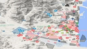
In July 2022, Fujairah experienced one of the most severe floods in its history. The event followed exceptionally heavy rainfall, the highest recorded in the emirate in more than two decades. The floods caused tragic loss of life, extensive property damage, and serious disruption to infrastructure, emphasizing the need for better flood risk assessment and management.
Fujairah’s natural landscape plays an important role in how floods develop. The emirate covers a large area with mountainous terrain that influences weather patterns and rainfall distribution. Although the region typically receives low annual rainfall, the intense rainstorm of July 2022 far exceeded normal levels, leading to widespread flooding across multiple locations.
To better understand the extent of the damage, researchers used advanced Geographic Information System (GIS) technologies to study the flood. By combining satellite images with mapping tools, they created detailed flood maps and elevation charts that clearly show which areas were affected and why. These visual tools help explain how water moved through the landscape and where it accumulated most severely.
High-resolution satellite imagery played a key role in identifying flooded areas. Mapping software was used to outline affected zones and compare conditions before and after the flood. This approach made it possible to accurately measure the scale of the disaster and highlight the most vulnerable locations.
One of the most important findings was the link between flood risk and elevation. Areas closer to sea level were found to be more vulnerable to severe flooding, while higher areas generally experienced less damage. However, elevation alone was not the only factor. Other elements, such as heavy rainfall, nearby dams, and land features, also influenced how severely an area was affected.
The results of this study demonstrate how GIS technology can support disaster planning and emergency response. Flood maps and elevation data can help authorities identify high-risk zones, improve infrastructure planning, and strengthen early warning systems. These tools are especially valuable as extreme weather events become more frequent due to climate change.
By using modern mapping and analysis techniques, communities can better prepare for future floods, reduce risks, and protect lives and property. The methods used in this study can also be applied in other regions facing similar challenges, supporting more resilient and informed flood management strategies worldwide.
Reference
Fujairah Research Centre